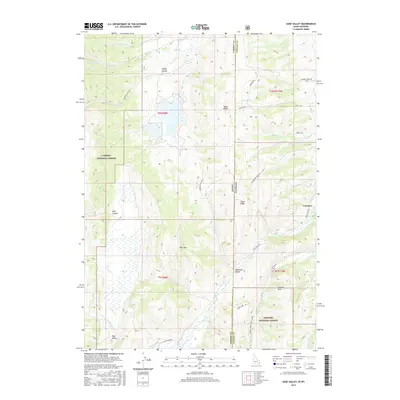
2017 Map of Sage Valley
USGS Topo · Published 2017About this map
Caribou National Forest and Bridger National Forest meet at the Idaho-Wyoming state line, a landscape defined by the high ridges and deep canyons of the Gannett Hills. The northern portion of the sheet is dominated by Smoky Canyon, which provides a corridor for Smokey Canyon Rd as it tracks alongside Smoky Cr. To the south, the terrain rises toward Buck Mtn before descending into the namesake Sage Valley. This 2017 survey details the complex network of drainage and transport that supports the region's remote settlements. In the east, the community of Fairview sits near the base of the hills, where Crow Creek Rd follows the winding path of Crow Cr. The map preserves the exact alignment of forest boundaries and mountain features such as Tygee Ridge and Hardmans Hollow, reflecting the intersection of protected wilderness and local access roads.
Find a feature on this map
38 named features on this map. Tap any name to fly to it.
Don’t see what you’re looking for? This feature index may not catch every label — zoom into the map to look around manually.
Map Details
Editions of this 2017 Sage Valley Map
This is the sole edition of this map. No revisions or reprints were ever made.
Other maps of this area

1915 · Freedom
USGS Topo · 1:62,500

1915 · Crow Creek
USGS Topo · 1:62,500

1921 · Afton
USGS Topo · 1:125,000

1949 · Stewart Flat
USGS Topo · 1:24,000

1949 · Snowdrift Mountain
USGS Topo · 1:24,000

1951 · Stewart Flat
USGS Topo · 1:24,000
1951 · Snowdrift Mountain
USGS Topo · 1:24,000

1955 · Preston
USGS Topo · 1:250,000

1958 · Preston
USGS Topo · 1:250,000

1962 · Preston
USGS Topo · 1:250,000