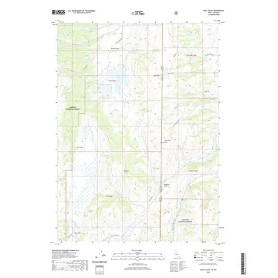
2020 Map of Sage Valley
USGS Topo · Published 2020About this map
Tygee Ridge and the Gannett Hills dominate this high-altitude landscape along the Idaho-Wyoming border, where the boundaries of the Caribou National Forest and Bridger National Forest meet. The terrain is defined by a series of north-south running valleys and canyons, including the prominent Smoky Canyon and Sage Valley. A network of watercourses like Tygee Creek, Roberts Creek, and Salt Lick Cr drain the slopes of Buck Mtn. This modern survey illustrates the specialized infrastructure of the region, from the winding path of Smokey Canyon Rd to remote tracks like Harmony Creek Dr and Merritt Dr. The map provides a clear picture of the complex drainage patterns and topographic relief in this interstate borderland, where Hardmans Hollow and Pole Canyon carve into the high ridges.
Find a feature on this map
43 named features on this map. Tap any name to fly to it.
Don’t see what you’re looking for? This feature index may not catch every label — zoom into the map to look around manually.
Map Details
Editions of this 2020 Sage Valley Map
This is the sole edition of this map. No revisions or reprints were ever made.
Other maps of this area

1915 · Freedom
USGS Topo · 1:62,500

1915 · Crow Creek
USGS Topo · 1:62,500

1921 · Afton
USGS Topo · 1:125,000

1949 · Stewart Flat
USGS Topo · 1:24,000

1949 · Snowdrift Mountain
USGS Topo · 1:24,000

1951 · Stewart Flat
USGS Topo · 1:24,000
1951 · Snowdrift Mountain
USGS Topo · 1:24,000

1955 · Preston
USGS Topo · 1:250,000

1958 · Preston
USGS Topo · 1:250,000

1962 · Preston
USGS Topo · 1:250,000