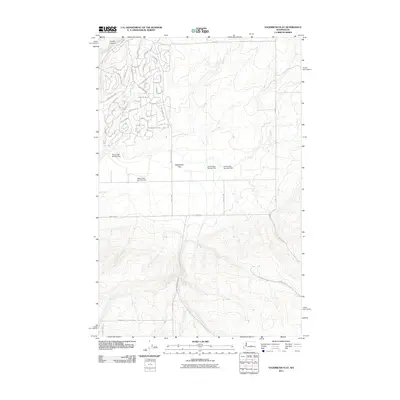
2011 Map of Sagebrush Flat
USGS Topo · Published 2011About this map
Sagebrush Flat in Douglas County reveals a landscape where modern residential development meets the traditional water management infrastructure of Washington's arid interior. The northwestern corner shows an organized grid of residential streets with evocative names like Tumbleweed Trl, Snaffle Ct, and Chief Moses Dr, indicating the expansion of rural subdivisions. This growth is juxtaposed against the critical irrigation and drainage network represented by Meyer Dam Number One, Meyer Dam Number Two, and the Kohne Dam Number One system. South of this developed pocket, the terrain transitions into the steep, deeply etched contours of Coyote Canyon. The map provides a clear look at how human habitation is structured around the natural draws and the plateau of the Sagebrush Flats Rd corridor.
Find a feature on this map
44 named features on this map. Tap any name to fly to it.
Don’t see what you’re looking for? This feature index may not catch every label — zoom into the map to look around manually.
Map Details
Editions of this 2011 Sagebrush Flat Map
This is the sole edition of this map. No revisions or reprints were ever made.
Other maps of this area

1953 · Ritzville
USGS Topo · 1:250,000

1956 · Ephrata
USGS Topo · 1:62,500

1956 · Ephrata
USGS Topo · 1:24,000

1956 · Ephrata SW
USGS Topo · 1:24,000

1959 · Ritzville
USGS Topo · 1:250,000

1965 · Ritzville
USGS Topo · 1:250,000

1965 · Jameson Lake SW
USGS Topo · 1:24,000

1965 · Jameson Lake SE
USGS Topo · 1:24,000
1966 · Monument Hill
USGS Topo · 1:24,000
1966 · Rattlesnake Springs
USGS Topo · 1:24,000