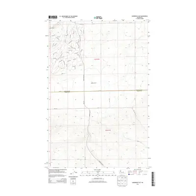
2014 Map of Sagebrush Flat
USGS Topo · Published 2014About this map
Sagebrush Flat and the dramatic incision of Coyote Canyon define the high plateau landscape of central Washington at the transition between Douglas and Grant counties. This 2014 survey reveals a unique mid-century residential or recreational subdivision layout characterized by an extensive network of streets with equestrian-themed names, such as Tumbleweed Way, Snaffle, and Roughbreed Dr. The presence of labels like Settler and Chief alongside Cornucopia Dr suggest a planned community development carved into the arid terrain. The map captures the interface between these modern rural residential parcels and the sprawling open spaces of the flat, anchored by the primary north-south artery of Moses Coulee Rd SE.
Find a feature on this map
60 named features on this map. Tap any name to fly to it.
Don’t see what you’re looking for? This feature index may not catch every label — zoom into the map to look around manually.
Map Details
Editions of this 2014 Sagebrush Flat Map
This is the sole edition of this map. No revisions or reprints were ever made.
Other maps of this area

1953 · Ritzville
USGS Topo · 1:250,000

1956 · Ephrata
USGS Topo · 1:62,500

1956 · Ephrata
USGS Topo · 1:24,000

1956 · Ephrata SW
USGS Topo · 1:24,000

1959 · Ritzville
USGS Topo · 1:250,000

1965 · Ritzville
USGS Topo · 1:250,000

1965 · Jameson Lake SW
USGS Topo · 1:24,000

1965 · Jameson Lake SE
USGS Topo · 1:24,000
1966 · Monument Hill
USGS Topo · 1:24,000
1966 · Rattlesnake Springs
USGS Topo · 1:24,000