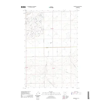
2020 Map of Sagebrush Flat
USGS Topo · Published 2020About this map
Sagebrush Flat anchors this landscape in Central Washington, where the boundary between Douglas and Grant Counties cuts across a complex grid of residential development north of the flat. The northern portion of the map reveals an intricate network of streets with equestrian and frontier-inspired names such as Jack Mountain Dr, Hackamore Dr, and Remuda Dr. This dense concentration of named roads, including Cornucopia Dr and Whiffletree Way, suggests a planned rural-residential community characterized by a systematic layout that contrasts with the open terrain to the south.
Find a feature on this map
64 named features on this map. Tap any name to fly to it.
Don’t see what you’re looking for? This feature index may not catch every label — zoom into the map to look around manually.
Map Details
Editions of this 2020 Sagebrush Flat Map
This is the sole edition of this map. No revisions or reprints were ever made.
Other maps of this area

1953 · Ritzville
USGS Topo · 1:250,000

1956 · Ephrata
USGS Topo · 1:62,500

1956 · Ephrata
USGS Topo · 1:24,000

1956 · Ephrata SW
USGS Topo · 1:24,000

1959 · Ritzville
USGS Topo · 1:250,000

1965 · Ritzville
USGS Topo · 1:250,000

1965 · Jameson Lake SW
USGS Topo · 1:24,000

1965 · Jameson Lake SE
USGS Topo · 1:24,000
1966 · Monument Hill
USGS Topo · 1:24,000
1966 · Rattlesnake Springs
USGS Topo · 1:24,000