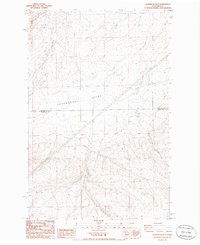
1985 Map of Sagebrush Flat
USGS Topo · Published 1985About this map
Sagebrush Flat dominates this high plateau landscape along the border of Douglas and Grant counties in the mid-1980s. The topography is defined by the sharp descent of Coyote Canyon in the northwest and the prominent elevation of Mc Cartney, surrounded by a network of unimproved roads and survey lines. Water access in this arid stretch of Washington is marked by scattered wells and a spring, indicating the importance of groundwater for the few agricultural or ranching operations present. A significant levee cuts across the flat, while high-voltage transmission lines traverse the terrain, reflecting the integration of this remote area into the regional power grid. The map captures the geometric precision of the township and range system where Douglas and Grant counties meet, providing a clear record of land division in this section of the Columbia Basin.
Find a feature on this map
11 named features on this map. Tap any name to fly to it.
Don’t see what you’re looking for? This feature index may not catch every label — zoom into the map to look around manually.
Map Details
Editions of this 1985 Sagebrush Flat Map
This is the sole edition of this map. No revisions or reprints were ever made.
Other maps of this area

1953 · Ritzville
USGS Topo · 1:250,000

1956 · Ephrata
USGS Topo · 1:62,500

1956 · Ephrata
USGS Topo · 1:24,000

1956 · Ephrata SW
USGS Topo · 1:24,000

1959 · Ritzville
USGS Topo · 1:250,000

1965 · Ritzville
USGS Topo · 1:250,000

1965 · Jameson Lake SW
USGS Topo · 1:24,000

1965 · Jameson Lake SE
USGS Topo · 1:24,000
1966 · Monument Hill
USGS Topo · 1:24,000
1966 · Rattlesnake Springs
USGS Topo · 1:24,000