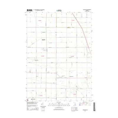
2014 Map of Saginaw NE
USGS Topo · Published 2014About this map
Frankentrost and Indiantown anchor this rural landscape northeast of the Bridgeport community, where the drainage patterns of the Saginaw Valley are clearly defined. The area is intersected by several critical water management features such as English Drain, Weaver Drain, and Fink Drain, reflecting the agricultural importance of managing the low-lying terrain near Cheboyganing Cr. Genealogists will find several notable burial grounds throughout the quadrangle, including E Lawn Memorial Gardens, Saint Johns Cem, and Buena Vista Cem. The presence of the Saginaw County H.W. Browne Airport west of N Airport Rd provides a landmark for the transition from open farmland to more developed infrastructure. The grid of country roads, from Wadsworth Rd to Janes Rd, outlines a landscape that has maintained its distinct township structure into the early 21st century.
Find a feature on this map
72 named features on this map. Tap any name to fly to it.
Don’t see what you’re looking for? This feature index may not catch every label — zoom into the map to look around manually.
Map Details
Editions of this 2014 Saginaw NE Map
This is the sole edition of this map. No revisions or reprints were ever made.
Other maps of this area

1916 · Bay City
USGS Topo · 1:62,500

1919 · Bay City
USGS Topo · 1:62,500

1919 · Saginaw
USGS Topo · 1:62,500

1941 · Saginaw
USGS Topo · 1:62,500

1943 · Bay City
USGS Topo · 1:62,500

1943 · Saginaw
USGS Topo · 1:62,500

1954 · Flint
USGS Topo · 1:250,000

1958 · Flint
USGS Topo · 1:250,000

1963 · Quanicassee
USGS Topo · 1:24,000

1963 · Reese
USGS Topo · 1:24,000
Featured Places
- Bridgeport Charter Township, MI
- Frankentrost, MI
- Frankenmuth Township, MI
- Buena Vista Charter Township, MI
- Merritt Township, MI