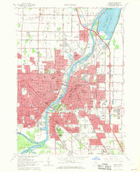
1967 Map of Saginaw
USGS Topo · Published 1969About this map
The Saginaw River serves as the central artery of this industrial and residential landscape, where four major rivers—the Saginaw, Shiawassee, Tittabasse, and Cass River—converge. This late-1960s survey captures Saginaw during a period of dense urban development, showing a grid of neighborhood schools and parish institutions like St Joseph Sch and St Marys Hospital. The map detail reveals the city's heavy reliance on rail, with the Penn Central, Grand Trunk Western RR, and Chesapeake and Ohio lines lacing through the industrial corridors and across the water.
Find a feature on this map
111 named features on this map. Tap any name to fly to it.
Don’t see what you’re looking for? This feature index may not catch every label — zoom into the map to look around manually.
Map Details
Editions of this 1967 Saginaw Map
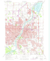
2 editions found
Other maps of this area

1916 · Bay City
USGS Topo · 1:62,500

1917 · St. Charles
USGS Topo · 1:62,500

1919 · Bay City
USGS Topo · 1:62,500

1919 · Saginaw
USGS Topo · 1:62,500

1941 · Saginaw
USGS Topo · 1:62,500

1943 · Bay City
USGS Topo · 1:62,500

1943 · Saginaw
USGS Topo · 1:62,500

1943 · St. Charles
USGS Topo · 1:62,500

1954 · Midland
USGS Topo · 1:250,000

1954 · Flint
USGS Topo · 1:250,000