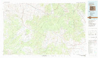
1982 Map of Saguache
USGS Topo · Published 1983About this map
The Continental Divide snake-like through the center of this region, separating the high headwaters of the Rio Grande from the western drainages of the Gunnison National Forest. In the early 1980s, this landscape remained a critical intersection of mining history and high-altitude ranching, centered on the town of Saguache. To the northeast, the Sawatch Range towers over the valley, while the Cochetopa Hills bridge the gap between the major wilderness areas.
Find a feature on this map
44 named features on this map. Tap any name to fly to it.
Don’t see what you’re looking for? This feature index may not catch every label — zoom into the map to look around manually.
Map Details
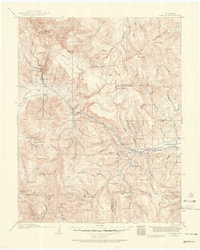
Editions of this 1982 Saguache Map
This is the sole edition of this map. No revisions or reprints were ever made.
Other maps of this area

1905 · San Cristobal
USGS Topo · 1:125,000

1907 · San Cristobal
USGS Topo · 1:125,000

1908 · Uncompahgre
USGS Topo · 1:125,000

1911 · Uncompahgre
USGS Topo · 1:125,000
1914 · Creede
USGS Topo · 1:125,000
1915 · Del Norte
USGS Topo · 1:125,000
1916 · Creede
USGS Topo · 1:125,000
1917 · Del Norte
USGS Topo · 1:125,000

1940 · Garfield
USGS Topo · 1:62,500
1941 · Pitkin
USGS Topo · 1:62,500