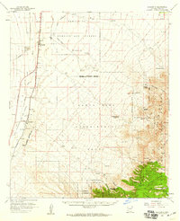
1958 Map of Sahuarita
USGS Topo · Published 1959About this map
The Santa Rita Experimental Range and its network of observation towers dominate the central landscape of this Pima County survey. To the north, the Bombing and Gunnery Range extends across the desert floor, featuring a prominent landing strip and markers for a military reservation boundary. The western edge of the map is anchored by the Santa Cruz River, where the Southern Pacific railroad parallels the Tucson-Nogales Highway, connecting the agricultural and rail hubs of Sahuarita and Continental.
Find a feature on this map
46 named features on this map. Tap any name to fly to it.
Don’t see what you’re looking for? This feature index may not catch every label — zoom into the map to look around manually.
Map Details
Editions of this 1958 Sahuarita Map
3 editions found
Other maps of this area

1904 · Patagonia
USGS Topo · 1:125,000

1904 · Tucson
USGS Topo · 1:125,000

1905 · Patagonia
USGS Topo · 1:125,000

1905 · Tucson
USGS Topo · 1:125,000

1920 · Arivaca
USGS Topo · 1:125,000

1922 · Agus Caliente
USGS Topo · 1:62,500

1925 · Samaniego Peak
USGS Topo · 1:62,500

1925 · San Xavier
USGS Topo · 1:62,500

1926 · Helvetia
USGS Topo · 1:62,500

1932 · Elgin
USGS Topo · 1:62,500