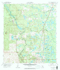
1958 Map of Saint Catherine
USGS Topo · Published 1970About this map
The Withlacoochee River carves a winding path through the center of this landscape, defining the border between Sumter and Hernando Counties. The river is flanked by the extensive Withlacoochee State Forest, which contains a mix of wet prairies and sinkholes characteristic of the Central Florida interior. Settlements like Saint Catherine, Croom, and Rerdell appear as modest rail-oriented hubs along the Atlantic Coast Line and Seaboard Air Line corridors, reflecting the region's historical reliance on transit and timber. Evidence of local industry is visible in several quarries and a phosphate pit near the forest edge.
Find a feature on this map
57 named features on this map. Tap any name to fly to it.
Don’t see what you’re looking for? This feature index may not catch every label — zoom into the map to look around manually.
Map Details
Editions of this 1958 Saint Catherine Map
3 editions found
Other maps of this area

1954 · Spring Lake
USGS Topo · 1:24,000

1954 · Nobleton
USGS Topo · 1:24,000

1954 · Brooksville SE
USGS Topo · 1:24,000

1955 · Plant City
USGS Topo · 1:250,000

1958 · Plant City
USGS Topo · 1:250,000

1958 · Webster
USGS Topo · 1:24,000

1958 · Bushnell
USGS Topo · 1:24,000

1958 · Wahoo
USGS Topo · 1:24,000

1958 · Saint Catherine
USGS Topo · 1:24,000

1959 · Plant City
USGS Topo · 1:250,000