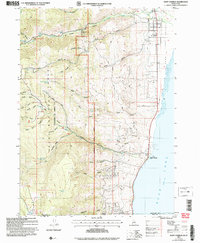
2005 Map of Saint Charles
USGS Topo · Published 2007About this map
St Charles and Fish Haven occupy the western shoreline of Bear Lake, where the high plateau of the Cache National Forest drops sharply into the Bear Lake Valley. This landscape reflects a century of mixed land use, from the small-scale extraction at Blackstone Mine to the established lakeside infrastructure of Boat Docks. The hydrology of the region is particularly dense, with numerous water sources like St Charles Creek and Fish Haven Creek cutting through the steep canyons. In the western mountains, high-altitude features like Swan Flat and the Ranger Dip indicate the area's history of forest management and grazing, while the numerous hollows and ridges, such as Hogstack Ridge, define the difficult terrain between the lake and the forest interior. This survey also records the precise Idaho-Utah state line as it passes through the southern portion of the quadrangle.
Find a feature on this map
53 named features on this map. Tap any name to fly to it.
Don’t see what you’re looking for? This feature index may not catch every label — zoom into the map to look around manually.
Map Details
Editions of this 2005 Saint Charles Map
This is the sole edition of this map. No revisions or reprints were ever made.
Other maps of this area

1909 · Montpelier
USGS Topo · 1:125,000

1911 · Montpelier
USGS Topo · 1:125,000

1912 · Randolph
USGS Topo · 1:125,000

1914 · Logan
USGS Topo · 1:125,000

1915 · Preston
USGS Topo · 1:96,000

1916 · Logan
USGS Topo · 1:125,000

1918 · Preston
USGS Topo · 1:125,000

1954 · Ogden
USGS Topo · 1:250,000

1955 · Preston
USGS Topo · 1:250,000

1958 · Ogden
USGS Topo · 1:250,000