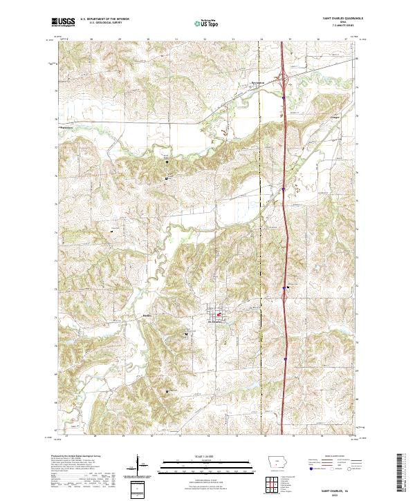
2022 Map of Saint Charles
USGS Topo · Published 2022About this map
St. Charles and its surrounding rural townships sit at the crossing of the Madison Co and Warren Co line. The topography is defined by the winding course of the Middle River to the north and Clanton Cr through the center, creating a landscape of ridges and drainage basins. Small settlements like Patterson and Bevington anchor the northern reaches of the quadrangle, while Hanley and Conger mark historical transit points in the southern and eastern sectors. Genealogists will find a concentration of burial sites throughout the countryside, including Montpelier Cem, Close Cem, and the Blair Chapel Cem located near Blair Chapel. The local road network, featuring names like Valleyview Trl and Imes Bridge Rd, reveals the enduring rural character of this agricultural region on the approach to South Central Iowa.
Find a feature on this map
77 named features on this map. Tap any name to fly to it.
Don’t see what you’re looking for? This feature index may not catch every label — zoom into the map to look around manually.
Map Details
Editions of this 2022 Saint Charles Map
This is the sole edition of this map. No revisions or reprints were ever made.
Other maps of this area

1931 · Indianola
USGS Topo · 1:62,500

1950 · New Virginia
USGS Topo · 1:62,500

1951 · Osceola
USGS Topo · 1:62,500

1951 · St. Charles
USGS Topo · 1:62,500

1952 · New Virginia
USGS Topo · 1:62,500

1954 · Des Moines
USGS Topo · 1:250,000

1956 · Des Moines
USGS Topo · 1:250,000

1957 · Des Moines
USGS Topo · 1:250,000

1969 · Des Moines
USGS Topo · 1:250,000
1972 · Norwalk
USGS Topo · 1:24,000