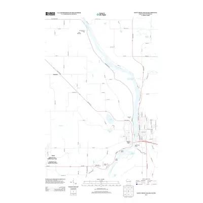
2013 Map of Saint Croix Dalles
USGS Topo · Published 2013About this map
The Saint Croix River carves a dramatic path through this 2013 survey, defining the border between Minnesota and Wisconsin at the historic river town of Taylors Falls. The landscape is shaped by the presence of the Ice Age National Scenic Trail, which winds through the rugged terrain of the Saint Croix Dalles. Recreation is central to the area's identity, shown through the Wild Mountain Ski Area Water Park in the north and several campgrounds like Wildwood RV Park Campground. Smaller settlements and developments such as Palmdale, Shafer, and the South Terrace Mobile Home Park sit back from the river bluffs, while numerous glacial water bodies like Wyckstrom Lake and Lake O' the Dalles dot the plateau. The map details a mix of small-town infrastructure, including the Taylors Falls Airport and local landmarks like Camp Waub-O-Jeeg.
Find a feature on this map
98 named features on this map. Tap any name to fly to it.
Don’t see what you’re looking for? This feature index may not catch every label — zoom into the map to look around manually.
Map Details
Editions of this 2013 Saint Croix Dalles Map
This is the sole edition of this map. No revisions or reprints were ever made.
Other maps of this area

1900 · St Croix Dalles
USGS Topo · 1:62,500

1901 · St Croix Dalles
USGS Topo · 1:62,500

1950 · Rush City
USGS Topo · 1:48,000

1951 · Milltown
USGS Topo · 1:48,000

1953 · Stillwater
USGS Topo · 1:250,000

1955 · St. Croix Dalles
USGS Topo · 1:62,500

1955 · Rush City
USGS Topo · 1:62,500

1955 · Milltown
USGS Topo · 1:62,500

1955 · Forest Lake
USGS Topo · 1:62,500

1955 · Stillwater
USGS Topo · 1:250,000