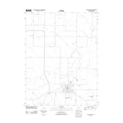
2012 Map of Saint Francis
USGS Topo · Published 2012About this map
Saint Francis serves as the focal point of this Cheyenne County landscape, situated where the S Fork Republican River winds through the high plains. The town's grid is clearly defined by streets such as Felzien St and Scott St, flanked by essential community hubs including the Po and the Cheyenne County Fairgrounds. The map details a transition from the structured residential and commercial blocks of the town to the vast agricultural sections and drainage networks that characterize the surrounding region.
Find a feature on this map
42 named features on this map. Tap any name to fly to it.
Don’t see what you’re looking for? This feature index may not catch every label — zoom into the map to look around manually.
Map Details
Editions of this 2012 Saint Francis Map
This is the sole edition of this map. No revisions or reprints were ever made.
Other maps of this area

1942 · St. Francis
USGS Topo · 1:62,500

1943 · St. Francis
USGS Topo · 1:62,500

1951 · St Francis
USGS Topo · 1:62,500

1951 · Bird City North
USGS Topo · 1:62,500

1951 · Bird City South
USGS Topo · 1:62,500

1952 · St Francis 3
USGS Topo · 1:62,500

1954 · Goodland
USGS Topo · 1:250,000

1956 · Goodland
USGS Topo · 1:250,000

1957 · Goodland
USGS Topo · 1:250,000
1976 · White Canyon
USGS Topo · 1:24,000