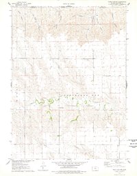
1976 Map of White Canyon
USGS Topo · Published 1978About this map
The High Plains of northwest Kansas meet the Nebraska border in this topographic study, where deep drainages carve through the arid tablelands of Cheyenne County. The landscape is defined by a series of north-running draws, including Wilson Canyon, Jackson Canyon, and the central White Canyon, which flow toward the state line. Farther south, the terrain transitions into the more defined drainage of Hackberry Creek, where human activity becomes more visible. Near the creek, Hackberry Cem serves as a small but significant marker of local history, situated just west of the Sandpits operations. In the southeastern portion of the quadrangle, the headwaters of Cleveland Run emerge, highlighting the intricate watershed patterns that dictate the agricultural and ranching potential of this corner of the state during the mid-1970s.
Find a feature on this map
19 named features on this map. Tap any name to fly to it.
Don’t see what you’re looking for? This feature index may not catch every label — zoom into the map to look around manually.
Map Details
Editions of this 1976 White Canyon Map
This is the sole edition of this map. No revisions or reprints were ever made.
Other maps of this area

1942 · St. Francis
USGS Topo · 1:62,500

1943 · St. Francis
USGS Topo · 1:62,500

1951 · St Francis
USGS Topo · 1:62,500

1951 · Bird City North
USGS Topo · 1:62,500

1954 · McCook
USGS Topo · 1:250,000

1954 · Goodland
USGS Topo · 1:250,000

1956 · Goodland
USGS Topo · 1:250,000

1957 · McCook
USGS Topo · 1:250,000

1957 · Goodland
USGS Topo · 1:250,000

1958 · McCook
USGS Topo · 1:250,000