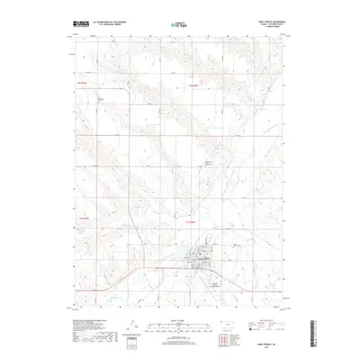
2018 Map of Saint Francis
USGS Topo · Published 2018About this map
The S Fork Republican River defines the lower third of this landscape as it flows past Saint Francis, the county seat of Cheyenne County. This 2018 survey illustrates a classic High Plains settlement pattern where the town is centered on a grid of numbered streets like 1st St and 4th St, as well as named thoroughfares such as Whittier Ave and W Spencer St. Several burial grounds are documented here, including the Zion Evangelical Cem to the northwest and the Grand Army of the Republic Cem north of the river, offering precise locations for genealogical research. The terrain is deeply carved by numerous intermittent drainage systems such as Plum Cr, Fish Cr, and Cleveland Run which all feed into the river valley. Modern infrastructure like the Cheyenne County Municipal Airport sits on the southern terrace above the river, contrasting with the established township and range divisions of t3s r40w.
Find a feature on this map
34 named features on this map. Tap any name to fly to it.
Don’t see what you’re looking for? This feature index may not catch every label — zoom into the map to look around manually.
Map Details
Editions of this 2018 Saint Francis Map
This is the sole edition of this map. No revisions or reprints were ever made.
Other maps of this area

1942 · St. Francis
USGS Topo · 1:62,500

1943 · St. Francis
USGS Topo · 1:62,500

1951 · St Francis
USGS Topo · 1:62,500

1951 · Bird City North
USGS Topo · 1:62,500

1951 · Bird City South
USGS Topo · 1:62,500

1952 · St Francis 3
USGS Topo · 1:62,500

1954 · Goodland
USGS Topo · 1:250,000

1956 · Goodland
USGS Topo · 1:250,000

1957 · Goodland
USGS Topo · 1:250,000
1976 · White Canyon
USGS Topo · 1:24,000