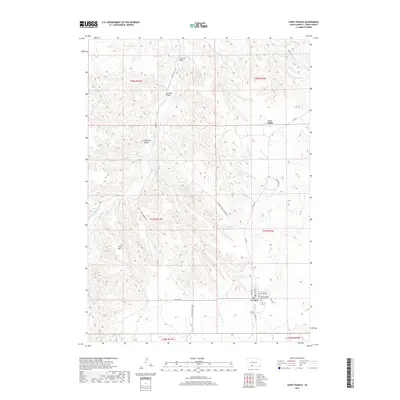
2017 Map of Saint Francis
USGS Topo · Published 2017About this map
St. Francis serves as the primary hub of this landscape on the Rosebud Indian Reservation, situated in the southern reaches of the map. The settlement is organized around a grid that includes Spruce St, Willow Ave, and the Saint Charles Catholic Cem, reflecting its role as a focal point for the community. The topography is defined by the winding course of the Little White River, which is joined by tributaries such as S Ironwood Cr and Beads Cr.
Find a feature on this map
30 named features on this map. Tap any name to fly to it.
Don’t see what you’re looking for? This feature index may not catch every label — zoom into the map to look around manually.
Map Details
Editions of this 2017 Saint Francis Map
This is the sole edition of this map. No revisions or reprints were ever made.
Other maps of this area

1955 · Martin
USGS Topo · 1:250,000

1958 · Martin
USGS Topo · 1:250,000

1969 · Soldier Creek
USGS Topo · 1:24,000

1969 · Parmelee
USGS Topo · 1:24,000

1969 · Iron Shell Flat East
USGS Topo · 1:24,000

1969 · Soldier Creek SE
USGS Topo · 1:24,000

1969 · Rosebud
USGS Topo · 1:24,000

1969 · Spring Creek
USGS Topo · 1:24,000

1969 · St. Francis SW
USGS Topo · 1:24,000
1969 · St. Francis
USGS Topo · 1:24,000
Featured Places
- Rosebud, SD
- St. Francis Segment, SD
- Two Strike Segment, SD
- Grass Mountain Segment, SD
- Two Strike, Two Strike Segment