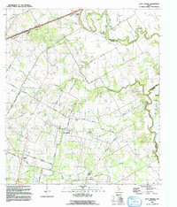
1992 Map of Saint Hedwig
USGS Topo · Published 1992About this map
Saint Hedwig and the surrounding rural communities of east Bexar County are captured here during a period of transition in the early 1990s. The landscape is defined by the winding paths of Cibolo Creek and Martinez Creek, where the local economy and travel patterns are anchored by historic road networks like Graytown Road and Lavernia Road. Evidence of the area's older transportation infrastructure is visible in the Saint Hedwig Railroad Grade and an Old Railroad Grade near Carpenter, marking the path of former rail lines that once served these agricultural settlements. Small crossroads and community centers such as Adkins, Friendly Corner, and Zuehl are noted, alongside local landmarks like Hebron Ch and Redeemer Ch. The presence of several Gravel Pits and a Borrow Pit suggests the ongoing extraction of local resources amidst the creek bottoms and hollows.
Find a feature on this map
43 named features on this map. Tap any name to fly to it.
Don’t see what you’re looking for? This feature index may not catch every label — zoom into the map to look around manually.
Map Details
Editions of this 1992 Saint Hedwig Map
This is the sole edition of this map. No revisions or reprints were ever made.
Other maps of this area

1924 · New Braunfels No 4
USGS Topo · 1:48,000

1927 · New Braunfels
USGS Topo · 1:62,500

1953 · Schertz
USGS Topo · 1:24,000

1953 · Elmendorf
USGS Topo · 1:24,000

1953 · Martinez
USGS Topo · 1:24,000

1954 · San Antonio
USGS Topo · 1:250,000

1957 · San Antonio
USGS Topo · 1:250,000

1957 · New Berlin
USGS Topo · 1:24,000

1958 · Marion
USGS Topo · 1:24,000

1958 · La Vernia SW
USGS Topo · 1:24,000