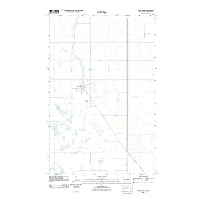
2011 Map of Saint John
USGS Topo · Published 2011About this map
Saint John serves as the primary settlement on this North Dakota prairie landscape, situated near the headwaters of Gimby Creek. The town's grid is defined by local thoroughfares such as St Ann St, Oakwood Dr, and Emma St, reflecting a residential hub just south of the international border. Outside the town limits, the terrain is characterized by numerous small glacial depressions and water bodies, most notably Byrnes Lake and Syrian Lake. The Saint John Cemetery is positioned south of the main town site along 45th Ave NE, providing a key location for genealogical research in Rolette County. A network of rural section lines and designated routes like County Hwy 43 and several Bureau of Indian Affairs roads, including BIA Road 7 and BIA Road 5, connect the agricultural parcels and remote lakeside properties across the quadrangle.
Find a feature on this map
31 named features on this map. Tap any name to fly to it.
Don’t see what you’re looking for? This feature index may not catch every label — zoom into the map to look around manually.
Map Details
Editions of this 2011 Saint John Map
This is the sole edition of this map. No revisions or reprints were ever made.
Other maps of this area

1936 · Lake Upsilon
USGS Topo · 1:48,000

1942 · Lake Upsilon
USGS Topo · 1:62,500

1953 · Devils Lake
USGS Topo · 1:250,000

1956 · Devils Lake
USGS Topo · 1:250,000

1968 · Lake Upsilon SE
USGS Topo · 1:24,000
1968 · Lake Upsilon
USGS Topo · 1:24,000

1968 · Belcourt
USGS Topo · 1:24,000

1969 · Saint John
USGS Topo · 1:24,000

1969 · Rolla NE
USGS Topo · 1:24,000

1970 · Rolla
USGS Topo · 1:24,000