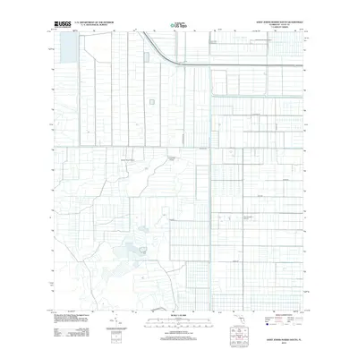
2012 Map of Saint Johns Marsh South
USGS Topo · Published 2012About this map
St Johns Marsh dominates the northern landscape of this Saint Lucie County region, where the vast drainage and irrigation patterns of Florida's agricultural interior are clearly visible. The map reveals a highly structured environment defined by a grid of canals and access roads, supporting large-scale grove operations and ranching. Multiple private airstrips, including Strazzulla Groves Airport, Adams Ranch Airport, Dragonfly Airport, and Southeastern Airport, underscore the logistical needs of these remote agricultural enterprises. This 2012 survey illustrates the intersection of industrial agriculture and the natural marshland, with named routes like Minute Maid Rd and Orange Ave reflecting the area's primary economic drivers. Researchers will find a landscape where water management and transportation are inextricably linked to the commercial history of the citrus and cattle industries.
Find a feature on this map
12 named features on this map. Tap any name to fly to it.
Don’t see what you’re looking for? This feature index may not catch every label — zoom into the map to look around manually.
Map Details
Editions of this 2012 Saint Johns Marsh South Map
This is the sole edition of this map. No revisions or reprints were ever made.
Other maps of this area

1949 · Oslo
USGS Topo · 1:24,000

1949 · Fort Pierce NW
USGS Topo · 1:24,000

1950 · Fort Pierce NW
USGS Topo · 1:24,000

1950 · Oslo
USGS Topo · 1:24,000

1953 · Okeechobee 1 SE
USGS Topo · 1:24,000

1953 · Fellsmere 4 SE
USGS Topo · 1:24,000

1953 · Fellsmere 4 SW
USGS Topo · 1:24,000

1953 · Okeechobee 1 SW
USGS Topo · 1:24,000

1953 · Okeechobee 1 NE
USGS Topo · 1:24,000

1953 · Okeechobee 1 NW
USGS Topo · 1:24,000