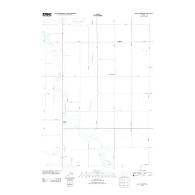
2013 Map of Saint Joseph
USGS Topo · Published 2013About this map
The winding E Fork Des Moines River defines the western landscape of this Kossuth County region, where the river's meandering oxbows contrast sharply with the rigid grid of the surrounding agricultural township. The small community of Saint Joseph sits near the river's edge, while the settlement of Galbraith occupies the northeastern corner of the map. This 2013 survey illustrates the sophisticated water management systems required for Iowa prairie farming, featuring extensive engineered waterways such as Drainage Ditch Number 182 and Drainage Ditch Number 8. These ditches coordinate with natural tributaries like Lotts Cr to drain the fertile till plains. Private infrastructure is also visible, most notably the Kohlhaas Airport situated among the section-line roads like 130th St and 150th Ave.
Find a feature on this map
37 named features on this map. Tap any name to fly to it.
Don’t see what you’re looking for? This feature index may not catch every label — zoom into the map to look around manually.
Map Details
Editions of this 2013 Saint Joseph Map
This is the sole edition of this map. No revisions or reprints were ever made.
Other maps of this area

1954 · Fairmont
USGS Topo · 1:250,000

1954 · Fort Dodge
USGS Topo · 1:250,000

1957 · Fort Dodge
USGS Topo · 1:250,000

1958 · Fort Dodge
USGS Topo · 1:250,000

1958 · Fairmont
USGS Topo · 1:250,000

1972 · Algona
USGS Topo · 1:24,000

1972 · St. Joseph
USGS Topo · 1:24,000
1972 · Sexton
USGS Topo · 1:24,000
1972 · Lu Verne
USGS Topo · 1:24,000

1972 · Livermore
USGS Topo · 1:24,000