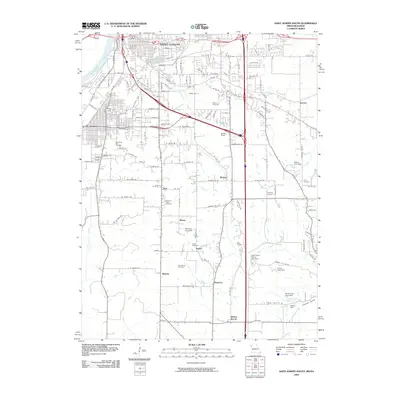
2009 Map of Saint Joseph South
USGS Topo · Published 2009About this map
Saint Joseph expands southward along the Missouri River in this 2009 survey, transitioning from the industrial and urban grid of the city into the smaller outlying communities of Buchanan County. The northern portion is marked by the rail activity at Terminal Junction and the prominent elevation of King Hill, while the surrounding landscape is dotted with long-established family and community burial grounds such as Old Sparta Cemetery and Feuquay Cemetery. These sites, along with small settlements like Matney, Richie, and Pinkston, indicate a rural residential pattern that persists despite the proximity of major transit corridors. Water management is a visible priority across the terrain, evidenced by several named earthen structures including Swanson Lake Dam and Ussary Dam, which regulate the drainages of Bee Creek and Pigeon Creek.
Find a feature on this map
138 named features on this map. Tap any name to fly to it.
Don’t see what you’re looking for? This feature index may not catch every label — zoom into the map to look around manually.
Map Details
Editions of this 2009 Saint Joseph South Map
This is the sole edition of this map. No revisions or reprints were ever made.
Other maps of this area

1923 · Clarksdale
USGS Topo · 1:62,500

1924 · St. Joseph
USGS Topo · 1:62,500

1925 · Gower
USGS Topo · 1:62,500

1925 · Clarksdale
USGS Topo · 1:62,500

1926 · Saint Joseph
USGS Topo · 1:62,500

1927 · Dearborn
USGS Topo · 1:62,500

1950 · Kansas City
USGS Topo · 1:250,000

1951 · Edgerton
USGS Topo · 1:24,000
1951 · De Kalb
USGS Topo · 1:24,000
1951 · Dearborn
USGS Topo · 1:24,000