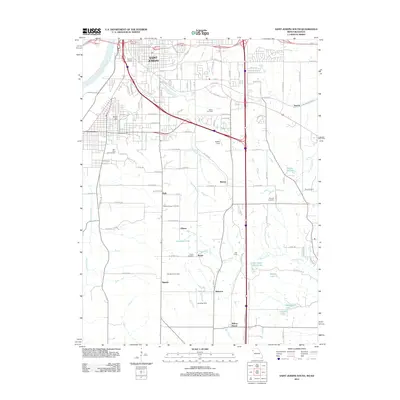
2012 Map of Saint Joseph South
USGS Topo · Published 2012About this map
The south side of Saint Joseph and the surrounding river bottoms of the Missouri River anchor this 2012 study of Buchanan County. Significant terrain features such as King Hill overlook a landscape transitioning from the urban density of Terminal Junction to the rural expanses of the Platte River drainage. The map provides a detailed view of the region's burial grounds, including the New King Hill Cemetery and Pleasant Ridge Cemetery, which serve as vital landmarks for local family historians. Small communities and named crossroads like Matney, Kyle, and Sparta are documented alongside numerous small bodies of water, such as Little Ozark Fishing Lake and Komer Lake. The prevalence of small private airfields like Butchs Strip and Landing Strip further characterizes the modern agricultural and residential layout of this Missouri-Kansas borderland area.
Find a feature on this map
107 named features on this map. Tap any name to fly to it.
Don’t see what you’re looking for? This feature index may not catch every label — zoom into the map to look around manually.
Map Details
Editions of this 2012 Saint Joseph South Map
This is the sole edition of this map. No revisions or reprints were ever made.
Other maps of this area

1923 · Clarksdale
USGS Topo · 1:62,500

1924 · St. Joseph
USGS Topo · 1:62,500

1925 · Gower
USGS Topo · 1:62,500

1925 · Clarksdale
USGS Topo · 1:62,500

1926 · Saint Joseph
USGS Topo · 1:62,500

1927 · Dearborn
USGS Topo · 1:62,500

1950 · Kansas City
USGS Topo · 1:250,000

1951 · Edgerton
USGS Topo · 1:24,000
1951 · De Kalb
USGS Topo · 1:24,000
1951 · Dearborn
USGS Topo · 1:24,000