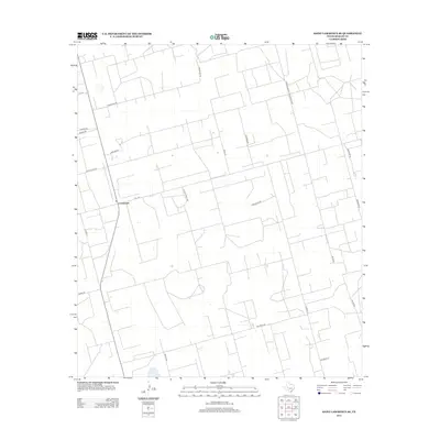
2012 Map of Saint Lawrence SE
USGS Topo · Published 2012About this map
The settlement of Crossroads serves as the primary hub for this Reagan County landscape, defined by a meticulously gridded system of ranch roads and farm-to-market routes. This West Texas terrain is intricately partitioned by long thoroughfares such as Farm-To-Market Road 3093 and Fm-1357, reflecting a rural economy organized around large-scale land tracts. Family names and local history are etched into the geography through markers like Cauble Ranch Rd and Cauble Ln, while more enigmatic labels like Forgotten Rd and Wolfs Way hint at the personal stories behind the region's development. The road network, including Houstons Rd and Willaims Rd, reveals a highly managed agricultural or ranching environment where every parcel is accessed by a dedicated lane, providing a clear view of modern Texas land use in the Permian Basin region.
Find a feature on this map
23 named features on this map. Tap any name to fly to it.
Don’t see what you’re looking for? This feature index may not catch every label — zoom into the map to look around manually.
Map Details
Editions of this 2012 Saint Lawrence SE Map
This is the sole edition of this map. No revisions or reprints were ever made.
Other maps of this area

1928 · Rankin
USGS Topo · 1:125,000

1954 · San Angelo
USGS Topo · 1:250,000

1958 · San Angelo
USGS Topo · 1:250,000

1965 · San Angelo
USGS Topo · 1:250,000

1970 · Stiles NW
USGS Topo · 1:24,000

1970 · Moore Hill
USGS Topo · 1:24,000

1970 · Stiles
USGS Topo · 1:24,000

1973 · Saint Lawrence SE
USGS Topo · 1:24,000

1973 · Bigby Corner
USGS Topo · 1:24,000
1973 · Slager Lake
USGS Topo · 1:24,000