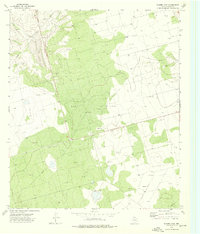
1973 Map of Slager Lake
USGS Topo · Published 1976About this map
Slager Lake and the surrounding desert landscape of Reagan County are defined by industrial infrastructure in this 1970s record of West Texas resource extraction. The map detail centers on a sprawling Oil Field that dominates the terrain, interconnected by a network of service roads and an extensive Pipeline system. While the lake provides a primary natural landmark, the topography is heavily marked by human activity, including numerous Oil Wells and a specific Pumping Sta located near the center of the survey. Scattered Gravel Pits suggest the local materials used to build the transit network required for such a concentrated petroleum operation. This survey offers a precise look at the land use patterns in the Permian Basin at a time when energy development was the primary driver of the local economy and landscape modification.
Find a feature on this map
7 named features on this map. Tap any name to fly to it.
Don’t see what you’re looking for? This feature index may not catch every label — zoom into the map to look around manually.
Map Details
Editions of this 1973 Slager Lake Map
This is the sole edition of this map. No revisions or reprints were ever made.
Other maps of this area

1928 · Rankin
USGS Topo · 1:125,000

1954 · San Angelo
USGS Topo · 1:250,000

1958 · San Angelo
USGS Topo · 1:250,000

1965 · San Angelo
USGS Topo · 1:250,000

1967 · Midkiff
USGS Topo · 1:24,000

1968 · Midkiff SE
USGS Topo · 1:24,000

1970 · Sevenmile Corner NE
USGS Topo · 1:24,000

1970 · Stiles NW
USGS Topo · 1:24,000

1970 · Stiles
USGS Topo · 1:24,000

1973 · Saint Lawrence SE
USGS Topo · 1:24,000