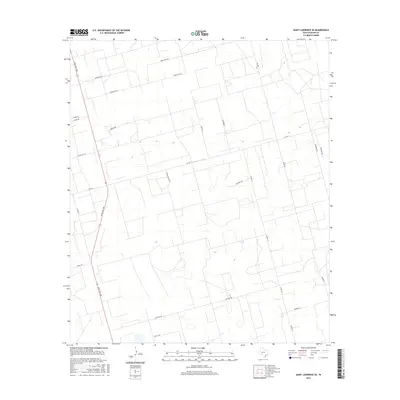
2016 Map of Saint Lawrence SE
USGS Topo · Published 2016About this map
Ranch Rd 1800 and Fm 1357 anchor this 2016 survey of Reagan County, Texas, revealing a landscape defined by an extensive grid of local ranch roads and access ways. The map illustrates a distinctive pattern of rural land use, where long, named lanes such as Cauble Ranch Rd, Perez Ln, and Wilde Rd stretch across the plains to serve isolated homesteads and ranching operations. The curious naming of Forgotten Rd in the north and the familial legacy suggested by Houston's Rd and Weishuhn Rd provide clear markers for local history and property research. This modern topographic study shows the infrastructure supporting West Texas ranching, including the network connecting Cotton Flat Rd to the southern reaches near Wolf's Way, during a period of continued development in the Permian Basin region.
Find a feature on this map
23 named features on this map. Tap any name to fly to it.
Don’t see what you’re looking for? This feature index may not catch every label — zoom into the map to look around manually.
Map Details
Editions of this 2016 Saint Lawrence SE Map
This is the sole edition of this map. No revisions or reprints were ever made.
Other maps of this area

1928 · Rankin
USGS Topo · 1:125,000

1954 · San Angelo
USGS Topo · 1:250,000

1958 · San Angelo
USGS Topo · 1:250,000

1965 · San Angelo
USGS Topo · 1:250,000

1970 · Stiles NW
USGS Topo · 1:24,000

1970 · Moore Hill
USGS Topo · 1:24,000

1970 · Stiles
USGS Topo · 1:24,000

1973 · Saint Lawrence SE
USGS Topo · 1:24,000

1973 · Bigby Corner
USGS Topo · 1:24,000
1973 · Slager Lake
USGS Topo · 1:24,000