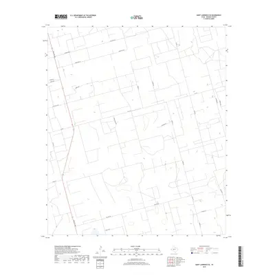
2019 Map of Saint Lawrence SE
USGS Topo · Published 2019About this map
Large ranching tracts and a geometric network of rural roads define this corner of Reagan County in the late 2010s. The landscape is dominated by the intersecting paths of Fm 1357 and Ranch Rd 1800, which provide the primary transit through this West Texas territory. The naming conventions of local routes like Cauble Ranch Rd, Cauble Ln, and Ricker Rd suggest the enduring presence of long-established agricultural families and landholdings. To the north, the evocative Forgotten Rd stretches across the plateau, while smaller local tracks such as Wolf's Way and Houston's Rd provide access to the interior of the quadrangle. This 2019 survey illustrates the specialized infrastructure of a modern Texas ranching district, where long-distance routes and private ranch roads create a distinct grid over the high plains.
Find a feature on this map
23 named features on this map. Tap any name to fly to it.
Don’t see what you’re looking for? This feature index may not catch every label — zoom into the map to look around manually.
Map Details
Editions of this 2019 Saint Lawrence SE Map
This is the sole edition of this map. No revisions or reprints were ever made.
Other maps of this area

1928 · Rankin
USGS Topo · 1:125,000

1954 · San Angelo
USGS Topo · 1:250,000

1958 · San Angelo
USGS Topo · 1:250,000

1965 · San Angelo
USGS Topo · 1:250,000

1970 · Stiles NW
USGS Topo · 1:24,000

1970 · Moore Hill
USGS Topo · 1:24,000

1970 · Stiles
USGS Topo · 1:24,000

1973 · Saint Lawrence SE
USGS Topo · 1:24,000

1973 · Bigby Corner
USGS Topo · 1:24,000
1973 · Slager Lake
USGS Topo · 1:24,000