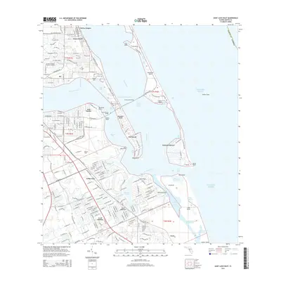
2015 Map of Saint Lucie Inlet
USGS Topo · Published 2015About this map
The confluence of the Indian River and the Saint Lucie River defines this coastal landscape on the Atlantic shore. This mid-2010s survey captures the dense residential and maritime infrastructure of Martin County, from the community of Jensen Beach down to Port Salerno. The map highlights the complex waterway network, including the Intracoastal Waterway passing through the Indian River Lagoon and the narrow passage at Saint Lucie Inlet. Significant local landmarks include Witham Field and the Ernest Lyons Bridge, which connects the mainland to Hutchinson Island. The detailed street grids of Golden Gate, Rio, and Sewall's Point reflect decades of coastal development, while the All Saints Cem near Skyline Heights provides a point of interest for genealogists tracking local families in this historically significant Florida maritime corridor.
Find a feature on this map
61 named features on this map. Tap any name to fly to it.
Don’t see what you’re looking for? This feature index may not catch every label — zoom into the map to look around manually.
Map Details
Editions of this 2015 Saint Lucie Inlet Map
This is the sole edition of this map. No revisions or reprints were ever made.
Other maps of this area

1948 · Palm City
USGS Topo · 1:24,000

1948 · Ankona
USGS Topo · 1:24,000

1948 · St. Lucie Inlet
USGS Topo · 1:24,000

1948 · Gomez
USGS Topo · 1:24,000

1948 · Hobe Sound
USGS Topo · 1:24,000

1948 · Eden
USGS Topo · 1:24,000

1949 · Gomez
USGS Topo · 1:24,000

1949 · Hobe Sound
USGS Topo · 1:24,000

1950 · St. Lucie Inlet
USGS Topo · 1:24,000

1950 · Ankona
USGS Topo · 1:24,000