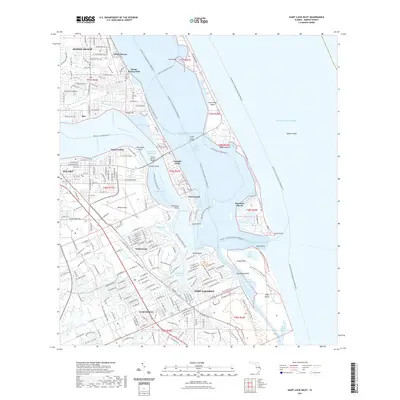
2021 Map of Saint Lucie Inlet
USGS Topo · Published 2021About this map
Jensen Beach and Port Salerno anchor this detailed coastal survey of the Martin County shoreline, where the Saint Lucie River meets the Atlantic Ocean. The landscape is defined by the intricate waterways of the Indian River Lagoon and the Intracoastal Waterway, framing the residential and maritime communities of Rio, Sewall's Point, and Seminole Shores. Notable landmarks include Witham Field and the All Saints Cem, alongside the protective barrier of Hutchinson Island. The presence of the Florida Circumnavigational Paddling Trl and the Martin County Blueway Trl highlights the area's modern emphasis on water-based recreation and conservation, particularly around the St. Lucie Inlet Preserve State Park Trl. The map illustrates a highly developed coastal corridor where residential expansion reaches right to the edge of the Manatee Pocket and Bessie Cove.
Find a feature on this map
226 named features on this map. Tap any name to fly to it.
Don’t see what you’re looking for? This feature index may not catch every label — zoom into the map to look around manually.
Map Details
Editions of this 2021 Saint Lucie Inlet Map
This is the sole edition of this map. No revisions or reprints were ever made.
Other maps of this area

1948 · Palm City
USGS Topo · 1:24,000

1948 · Ankona
USGS Topo · 1:24,000

1948 · St. Lucie Inlet
USGS Topo · 1:24,000

1948 · Gomez
USGS Topo · 1:24,000

1948 · Hobe Sound
USGS Topo · 1:24,000

1948 · Eden
USGS Topo · 1:24,000

1949 · Gomez
USGS Topo · 1:24,000

1949 · Hobe Sound
USGS Topo · 1:24,000

1950 · St. Lucie Inlet
USGS Topo · 1:24,000

1950 · Ankona
USGS Topo · 1:24,000