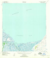
1952 Map of Saint Michael A-3
USGS Topo · Published 1958About this map
Pastol Bay and the vast waters of Norton Sound dominate this coastal landscape of the Yukon-Kuskokwim Delta region in the early 1950s. The intricate network of tidal channels and river mouths, including Apoon Pass and Apoon Mouth, illustrates a complex amphibious environment where land and water merge through various sloughs and marshes. Human presence is concentrated in small, riverside locations such as Nakhliwak and Chaniliut, alongside several Cabins. Navigational aids like the Pastol Bay Light and Pastolik River Lights highlight the importance of water travel for this region. On land, the Winter Trail provides a tenuous connection across the tundra, bypassing landmarks like Hogback Hill as it follows the southern coastline. This survey records a period when seasonal travel routes and river navigation were the primary means of movement between isolated settlements.
Find a feature on this map
19 named features on this map. Tap any name to fly to it.
Don’t see what you’re looking for? This feature index may not catch every label — zoom into the map to look around manually.
Map Details
Editions of this 1952 Saint Michael A-3 Map
2 editions found
Other maps of this area

1951 · St Michael
USGS Topo · 1:250,000

1952 · Kwiguk
USGS Topo · 1:250,000
1952 · Saint Michael B-2
USGS Topo · 1:63,360
1952 · Saint Michael A-4
USGS Topo · 1:63,360

1952 · Kwiguk D-2
USGS Topo · 1:63,360

1952 · Kwiguk D-3
USGS Topo · 1:63,360

1952 · Saint Michael A-2
USGS Topo · 1:63,360

1952 · Kwiguk D-4
USGS Topo · 1:63,360

1952 · St Michael
USGS Topo · 1:250,000

1964 · St. Michael
USGS Topo · 1:250,000