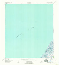
1952 Map of Saint Michael B-2
USGS Topo · Published 1958About this map
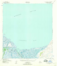
Norton Sound dominates this mid-century topographic perspective of the Alaska coastline, where the land dissolves into a complex network of marshes and waterways. The coastal lowlands are defined by the winding paths of the Pikmiktalik River and the Kogok River, which meander through a landscape predominantly under fifty feet in elevation. The cartography, based on 1951 aerial photography, reveals the vital seasonal transport routes of the era, specifically the Winter Trail that skirts the shoreline. A solitary Cabin situated near the riverbanks provides a rare point of human habitation in this subarctic environment, offering a specific location for those researching the early postwar occupancy and movement through the Second Judicial Division.
Find a feature on this map
5 named features on this map. Tap any name to fly to it.
Don’t see what you’re looking for? This feature index may not catch every label — zoom into the map to look around manually.
Map Details
Editions of this 1952 Saint Michael B-2 Map
2 editions found
Other maps of this area

1951 · St Michael
USGS Topo · 1:250,000
1952 · Saint Michael C-1
USGS Topo · 1:63,360
1952 · Saint Michael C-2
USGS Topo · 1:63,360

1952 · Saint Michael B-1
USGS Topo · 1:63,360
1952 · Saint Michael A-3
USGS Topo · 1:63,360

1952 · Saint Michael A-1
USGS Topo · 1:63,360

1952 · Saint Michael A-2
USGS Topo · 1:63,360

1952 · St Michael
USGS Topo · 1:250,000

1964 · St. Michael
USGS Topo · 1:250,000
2017 · Saint Michael C-2 SE
USGS Topo · 1:25,000