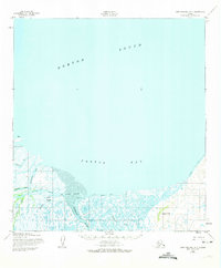
1952 Map of Saint Michael A-3
USGS Topo · Published 1974About this map
Pastolik River and the Pastoliak River converge near the southern shores of Pastol Bay, carving a complex network of waterways through the low-lying coastal tundra. This 1952 topographic survey, based on aerial photography from the early 1950s, documents a landscape defined by seasonal movement and maritime navigation. The presence of the Winter Trail stretching across the eastern reach suggests the vital overland routes used when the water froze, while the Pastolik River Lights and Pastol Bay Light indicate the importance of this delta for vessels navigating toward the Apoon Mouth. The site of Chaniliut sits near the junction of Apoon Pass and Kulmogon Slough, marking a historical point of human activity within this intricate system of sloughs and passes. Inland, Hogback Hill provides a rare point of elevation above the surrounding marshes and Nekutahalik Creek.
Find a feature on this map
18 named features on this map. Tap any name to fly to it.
Don’t see what you’re looking for? This feature index may not catch every label — zoom into the map to look around manually.
Map Details
Editions of this 1952 Saint Michael A-3 Map
2 editions found
Other maps of this area

1951 · St Michael
USGS Topo · 1:250,000

1952 · Kwiguk
USGS Topo · 1:250,000
1952 · Saint Michael B-2
USGS Topo · 1:63,360
1952 · Saint Michael A-4
USGS Topo · 1:63,360

1952 · Kwiguk D-2
USGS Topo · 1:63,360

1952 · Kwiguk D-3
USGS Topo · 1:63,360
1952 · Saint Michael A-3
USGS Topo · 1:63,360

1952 · Saint Michael A-2
USGS Topo · 1:63,360

1952 · Kwiguk D-4
USGS Topo · 1:63,360

1952 · St Michael
USGS Topo · 1:250,000