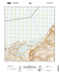
2020 Map of Saint Michael A-3 SE
USGS Topo · Published 2020About this map
Norton Sound defines the northern reaches of this coastal landscape along the edge of Pastol Bay. The terrain transitions from open water into a complex network of wetlands and tidal flats, where the Pastoliak River winds through the southwestern corner of the quadrangle. A distinct elevation change is found at Hogback Hill, which rises above the surrounding marshlands to provide a rare prominent landmark in this predominantly low-lying delta environment. The map captures the intricate hydrology of the region as it appeared in the early 21st century, illustrating the numerous small lakes and ponds that dominate the tundra east of the river's path.
Find a feature on this map
9 named features on this map. Tap any name to fly to it.
Don’t see what you’re looking for? This feature index may not catch every label — zoom into the map to look around manually.
Map Details
Editions of this 2020 Saint Michael A-3 SE Map
This is the sole edition of this map. No revisions or reprints were ever made.
Other maps of this area

1951 · St Michael
USGS Topo · 1:250,000

1952 · Kwiguk
USGS Topo · 1:250,000

1952 · Kwiguk D-2
USGS Topo · 1:63,360

1952 · Kwiguk D-3
USGS Topo · 1:63,360
1952 · Saint Michael A-3
USGS Topo · 1:63,360

1952 · Saint Michael A-2
USGS Topo · 1:63,360

1952 · St Michael
USGS Topo · 1:250,000

1964 · St. Michael
USGS Topo · 1:250,000
2017 · Saint Michael A-2 SW
USGS Topo · 1:25,000
2017 · Saint Michael A-2 NW
USGS Topo · 1:25,000