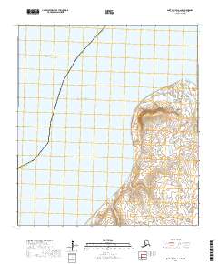
2017 Map of Saint Michael A-2 NW
USGS Topo · Published 2017About this map
Point Romanof stands as the primary landform on this coastal portion of the Kusilvak Census Area, where the marshy tundra of the Yukon-Kuskokwim Delta meets the sea. The geography is defined by a complex network of wetlands and small water bodies that lead toward the shores of Norton Sound and Pastol Bay. The map captures the transition from the open Pacific Ocean into the shallow, silt-heavy waters characteristic of the western Alaskan coastline. Moving inland, the drainage of Chakleyvik Creek provides a navigable reference point through the low-lying terrain. This 2017 survey reflects a landscape largely dictated by natural hydrology and shoreline shifts, showing the absence of permanent roads or settlements in this particular reach of the Bering Sea coast.
Find a feature on this map
12 named features on this map. Tap any name to fly to it.
Don’t see what you’re looking for? This feature index may not catch every label — zoom into the map to look around manually.
Map Details
Editions of this 2017 Saint Michael A-2 NW Map
This is the sole edition of this map. No revisions or reprints were ever made.
Other maps of this area

1951 · St Michael
USGS Topo · 1:250,000
1952 · Saint Michael B-2
USGS Topo · 1:63,360
1952 · Saint Michael A-3
USGS Topo · 1:63,360

1952 · Saint Michael A-2
USGS Topo · 1:63,360

1952 · St Michael
USGS Topo · 1:250,000

1964 · St. Michael
USGS Topo · 1:250,000
2017 · Saint Michael A-2 NE
USGS Topo · 1:25,000
2017 · Saint Michael A-2 SW
USGS Topo · 1:25,000
2017 · Saint Michael A-2 SE
USGS Topo · 1:25,000
2017 · Saint Michael B-2 SE
USGS Topo · 1:25,000