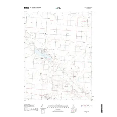
2019 Map of Saint Paris
USGS Topo · Published 2019About this map
St. Paris anchors the southern edge of this Champaign County landscape, where the street grid of the village meets the open agricultural fields and rolling drainage basins of central Ohio. The area is defined by a dense network of local cemeteries and small settlements, including Millerstown, Rosewood, and Carysville, reflecting generations of rural community life. Central to the geography is Kiser Lake, a significant water body featuring Ground Hog Island and surrounded by a detailed trail system including the Red, Blue, and Purple paths. North of the lake, the terrain transitions into a patchwork of woodlots and farms drained by Mosquito Cr and Nettle Cr. Genealogists will find a wealth of specific local landmarks, from the Heck Hill Grove and Zimmerman Cem to the Halterman Cem and Wilkson Cem, providing a precise record of historical burial sites across the townships.
Find a feature on this map
74 named features on this map. Tap any name to fly to it.
Don’t see what you’re looking for? This feature index may not catch every label — zoom into the map to look around manually.
Map Details
Editions of this 2019 Saint Paris Map
This is the sole edition of this map. No revisions or reprints were ever made.
Other maps of this area

1913 · Bellefontaine
USGS Topo · 1:48,000

1913 · Sidney
USGS Topo · 1:62,500

1914 · Troy
USGS Topo · 1:62,500

1914 · St. Paris
USGS Topo · 1:62,500

1915 · Bellefontaine
USGS Topo · 1:62,500

1916 · St. Paris
USGS Topo · 1:62,500

1944 · Sidney
USGS Topo · 1:62,500

1944 · St. Paris
USGS Topo · 1:62,500

1944 · Troy
USGS Topo · 1:62,500

1944 · Bellefontaine
USGS Topo · 1:62,500