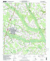
1997 Map of Saint Pauls
USGS Topo · Published 2000About this map
Saint Pauls serves as the primary hub of this North Carolina landscape, where the town grid is defined by its proximity to the Big Marsh Swamp and several active transportation corridors. The surrounding countryside reveals a mosaic of wetland features known as bays, including Evans Bay, Hopes Pond Bay, and White Pond Bay, which dictated the pattern of local agriculture and settlement. These geographical constraints shaped the development of smaller communities like Oakland and influenced the placement of numerous country churches such as Molloys Grove Ch and Antioch Ch.
Find a feature on this map
47 named features on this map. Tap any name to fly to it.
Don’t see what you’re looking for? This feature index may not catch every label — zoom into the map to look around manually.
Map Details
Editions of this 1997 Saint Pauls Map
This is the sole edition of this map. No revisions or reprints were ever made.
Other maps of this area

1953 · Florence
USGS Topo · 1:250,000

1954 · Florence
USGS Topo · 1:250,000

1957 · Bladenboro
USGS Topo · 1:62,500

1959 · Saint Pauls
USGS Topo · 1:62,500

1972 · Northwest Lumberton
USGS Topo · 1:24,000

1972 · Rennert
USGS Topo · 1:24,000
1972 · Parkton
USGS Topo · 1:24,000

1976 · Rennert
USGS Topo · 1:24,000
1976 · Northwest Lumberton
USGS Topo · 1:24,000

1976 · Parkton
USGS Topo · 1:24,000