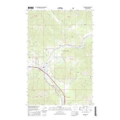
2017 Map of Saint Regis
USGS Topo · Published 2017About this map
Saint Regis serves as a central hub in this mountainous region of Mineral County, positioned where the Saint Regis River meets the larger Clark Fork. The settlement's layout is defined by the intersection of rail and road corridors, with Saint Regis Cem and a grid of local streets like St Regis St and Main St marking the town center. The surrounding landscape, much of it within the Lolo National Forest, is characterized by deep drainage systems and prominent peaks such as Cold Peak and Tamarack Hill. Numerous gulches, including Mayo Gulch and Graham Gulch, carve through the terrain, illustrating the complex hydrology that feeds into the river valley. The map also captures smaller communities like Toole and the winding paths of historical routes such as Old US Hwy 10, reflecting the area's development around these vital waterway and transportation arteries.
Find a feature on this map
63 named features on this map. Tap any name to fly to it.
Don’t see what you’re looking for? This feature index may not catch every label — zoom into the map to look around manually.
Map Details
Editions of this 2017 Saint Regis Map
This is the sole edition of this map. No revisions or reprints were ever made.
Other maps of this area

1918 · St Regis
USGS Topo · 1:125,000

1919 · St. Regis
USGS Topo · 1:125,000

1956 · St Regis
USGS Topo · 1:62,500

1956 · Wallace
USGS Topo · 1:250,000

1957 · Illinois Peak
USGS Topo · 1:62,500

1959 · Plains
USGS Topo · 1:62,500

1960 · Wallace
USGS Topo · 1:250,000

1960 · Superior
USGS Topo · 1:62,500
1985 · Superior
USGS Topo · 1:24,000
1985 · Plains
USGS Topo · 1:24,000