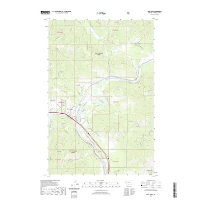
2020 Map of Saint Regis
USGS Topo · Published 2020About this map
The Saint Regis River meets the Clark Fork in this mountainous region of Lolo National Forest. The settlement of St. Regis serves as a central hub for the surrounding gulches and ridges, with the nearby Saint Regis Cem and the small siding of Toole marking the local footprint of Mineral County history. Steep elevations define the landscape, rising from the riverbanks to prominent summits like Cold Peak and Tamarack Hill.
Find a feature on this map
74 named features on this map. Tap any name to fly to it.
Don’t see what you’re looking for? This feature index may not catch every label — zoom into the map to look around manually.
Map Details
Editions of this 2020 Saint Regis Map
This is the sole edition of this map. No revisions or reprints were ever made.
Other maps of this area

1918 · St Regis
USGS Topo · 1:125,000

1919 · St. Regis
USGS Topo · 1:125,000

1956 · St Regis
USGS Topo · 1:62,500

1956 · Wallace
USGS Topo · 1:250,000

1957 · Illinois Peak
USGS Topo · 1:62,500

1959 · Plains
USGS Topo · 1:62,500

1960 · Wallace
USGS Topo · 1:250,000

1960 · Superior
USGS Topo · 1:62,500
1985 · Superior
USGS Topo · 1:24,000
1985 · Plains
USGS Topo · 1:24,000