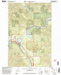
1999 Map of Saint Regis
USGS Topo · Published 2003About this map
St Regis sits at a critical junction of mountain travel in the late 1990s, where the waters of Clark Fork meet the surrounding peaks of the Lolo National Forest. The landscape is defined by the narrow river valley and the transportation corridors that follow it, including the St Regis-Paradise Scenic Byway. This survey captures the town as a functional forest service hub, evidenced by the St Regis Work Center, a Heliport, and a Gaging Station monitoring the river flow.
Find a feature on this map
33 named features on this map. Tap any name to fly to it.
Don’t see what you’re looking for? This feature index may not catch every label — zoom into the map to look around manually.
Map Details
Editions of this 1999 Saint Regis Map
This is the sole edition of this map. No revisions or reprints were ever made.
Other maps of this area

1918 · St Regis
USGS Topo · 1:125,000

1919 · St. Regis
USGS Topo · 1:125,000

1956 · St Regis
USGS Topo · 1:62,500

1956 · Wallace
USGS Topo · 1:250,000

1957 · Illinois Peak
USGS Topo · 1:62,500

1959 · Plains
USGS Topo · 1:62,500

1960 · Wallace
USGS Topo · 1:250,000

1960 · Superior
USGS Topo · 1:62,500
1985 · Superior
USGS Topo · 1:24,000
1985 · Plains
USGS Topo · 1:24,000