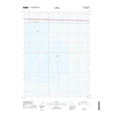
2020 Map of Salduro
USGS Topo · Published 2020About this map
Bonneville Salt Flats dominate this landscape within the larger Great Salt Lake Desert in western Utah. The terrain is defined by its extreme flatness, a remnant of a prehistoric lake bed that has left behind a vast expanse of evaporite minerals. This modern survey shows how transportation infrastructure cuts through this unique geological environment, primarily via the corridor of Interstate 80. Near the northern edge of the map lies Salduro, a location historically significant for its salt production and its position as a siding on the railroad. The stark geometry of the Public Land Survey System grid lines provides the only other markers across this otherwise open and feature-sparse desert basin.
Find a feature on this map
4 named features on this map. Tap any name to fly to it.
Don’t see what you’re looking for? This feature index may not catch every label — zoom into the map to look around manually.
Map Details
Editions of this 2020 Salduro Map
This is the sole edition of this map. No revisions or reprints were ever made.
Other maps of this area

1953 · Tooele
USGS Topo · 1:250,000

1955 · Tooele
USGS Topo · 1:250,000

1971 · Tetzlaff Peak
USGS Topo · 1:24,000

1971 · Bonneville Racetrack
USGS Topo · 1:24,000

1973 · Arinosa
USGS Topo · 1:24,000

1973 · Floating Island SW
USGS Topo · 1:24,000

1973 · Arinosa SW
USGS Topo · 1:24,000
1973 · Salduro SW
USGS Topo · 1:24,000

1973 · Salduro SE
USGS Topo · 1:24,000
1973 · Silsbee
USGS Topo · 1:24,000