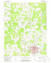
1981 Map of Salem
USGS Topo · Published 1982About this map
Salem serves as the regional hub for this part of Dent County, displaying a grid of civic infrastructure including the Courthouse, City Hall, and the Salem Memorial Hospital. The landscape is defined by the headwaters of Spring Creek and Dry Fork, where the terrain is marked by numerous family-named cemeteries such as Plank Cem, Gregory Cem, and Pace Cem. The area's industrial legacy is evident in the scattered mining operations, including the Plank Mine, Pomeroy Mine, and Simmons Hill Mine near the southern edge of the survey. The Burlington Northern railroad corridor cuts through the eastern half of the map, linking the small community of Howes to the larger county seat. This 1981 data reflects a mix of traditional Ozark land use and mid-century modernizations, from the Drive-in Theater and Country Club to older landmarks like Mt Olive Ch and Northwood Sch.
Find a feature on this map
63 named features on this map. Tap any name to fly to it.
Don’t see what you’re looking for? This feature index may not catch every label — zoom into the map to look around manually.
Map Details
Editions of this 1981 Salem Map
This is the sole edition of this map. No revisions or reprints were ever made.
Other maps of this area

1928 · Meramec Spring
USGS Topo · 1:62,500

1932 · Steelville
USGS Topo · 1:48,000

1933 · Steelville
USGS Topo · 1:62,500

1937 · Steelville
USGS Topo · 1:62,500

1941 · Salem
USGS Topo · 1:62,500

1941 · Stone Hill
USGS Topo · 1:62,500

1945 · Salem
USGS Topo · 1:62,500

1945 · Stone Hill
USGS Topo · 1:62,500

1949 · Rolla
USGS Topo · 1:250,000

1949 · Meramec Spring
USGS Topo · 1:62,500