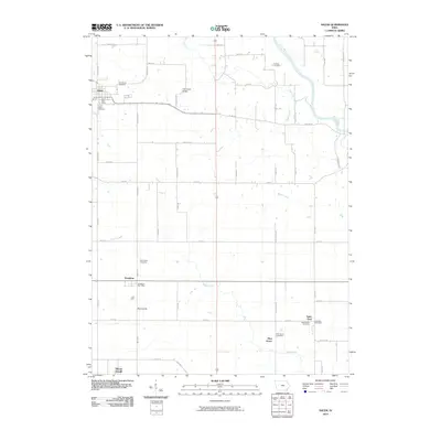
2010 Map of Salem
USGS Topo · Published 2010About this map
Salem and its surrounding rural townships are situated within a landscape defined by the winding course of the Skunk River and several local tributaries. This 2010 survey records the layout of numerous small agrarian settlements, including Houghton, Saint Paul, and Pilot Grove, which remain focal points for local commerce and community life. The distribution of several burial grounds, such as Saint John Cemetery and Saint James Cemetery, offers a clear spatial record of the area's genealogical history and family lineages.
Find a feature on this map
33 named features on this map. Tap any name to fly to it.
Don’t see what you’re looking for? This feature index may not catch every label — zoom into the map to look around manually.
Map Details
Editions of this 2010 Salem Map
This is the sole edition of this map. No revisions or reprints were ever made.
Other maps of this area

1936 · Fort Madison
USGS Topo · 1:62,500

1958 · Burlington
USGS Topo · 1:250,000

1961 · Burlington
USGS Topo · 1:250,000

1963 · Burlington
USGS Topo · 1:250,000

1964 · West Point
USGS Topo · 1:24,000

1968 · Donnellson
USGS Topo · 1:24,000

1968 · Farmington
USGS Topo · 1:24,000

1980 · Lockridge East
USGS Topo · 1:24,000

1981 · Mount Pleasant
USGS Topo · 1:24,000
1981 · Lowell
USGS Topo · 1:24,000