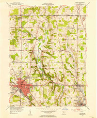
1952 Map of Salem
USGS Topo · Published 1954About this map
Salem serves as the industrial and social hub of the region in the early 1950s, bridging the boundary between Mahoning and Columbiana counties. The city's residential and commercial core is densely detailed, featuring neighborhood institutions like McKinley Sch and Reilly Sch, along with the central Centennial Park. The landscape to the north and east is defined by a series of agricultural hamlets and named crossroads, including New Albany, Greenford, and Calla, often centered around early gathering places like Concord Ch.
Find a feature on this map
62 named features on this map. Tap any name to fly to it.
Don’t see what you’re looking for? This feature index may not catch every label — zoom into the map to look around manually.
Map Details
Editions of this 1952 Salem Map
This is the sole edition of this map. No revisions or reprints were ever made.
Other maps of this area

1906 · Youngstown
USGS Topo · 1:62,500

1907 · Columbiana
USGS Topo · 1:62,500

1908 · Youngstown
USGS Topo · 1:62,500

1908 · Warren
USGS Topo · 1:62,500

1909 · Lisbon
USGS Topo · 1:62,500

1909 · Columbiana
USGS Topo · 1:62,500

1950 · Cleveland
USGS Topo · 1:250,000

1951 · Canton
USGS Topo · 1:250,000

1951 · Columbiana
USGS Topo · 1:24,000

1951 · Youngstown
USGS Topo · 1:24,000