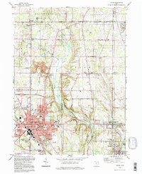
1994 Map of Salem
USGS Topo · Published 1997About this map
Salem anchors this landscape at the intersection of Mahoning and Columbiana counties, serving as a hub of civic life with its City Hall, Library, and Hospital facilities. The city's residential and industrial growth is framed by the Conrail line and organized around thoroughfares like E State St and S Ellsworth Ave. To the north, the terrain transitions into a patchwork of rural hamlets such as New Albany, Greenford, and Middletown, which are connected by a grid of agricultural routes including Western Reserve Road and Calla Road.
Find a feature on this map
80 named features on this map. Tap any name to fly to it.
Don’t see what you’re looking for? This feature index may not catch every label — zoom into the map to look around manually.
Map Details
Editions of this 1994 Salem Map
This is the sole edition of this map. No revisions or reprints were ever made.
Other maps of this area

1906 · Youngstown
USGS Topo · 1:62,500

1907 · Columbiana
USGS Topo · 1:62,500

1908 · Youngstown
USGS Topo · 1:62,500

1908 · Warren
USGS Topo · 1:62,500

1909 · Lisbon
USGS Topo · 1:62,500

1909 · Columbiana
USGS Topo · 1:62,500

1950 · Cleveland
USGS Topo · 1:250,000

1951 · Canton
USGS Topo · 1:250,000

1951 · Columbiana
USGS Topo · 1:24,000

1951 · Youngstown
USGS Topo · 1:24,000