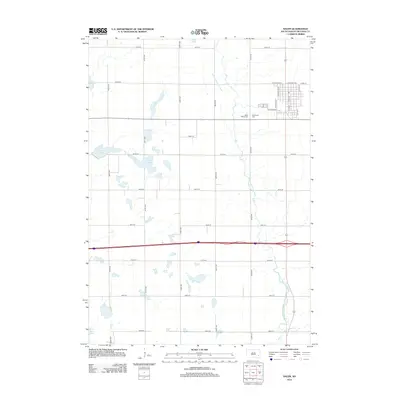
2012 Map of Salem
USGS Topo · Published 2012About this map
Salem serves as the primary municipal center in this McCook County landscape, characterized by a grid of agricultural section roads and the winding course of the W Fork Vermillion River. The town itself is organized around a traditional street plan, including N Main St and W Center Ave, while the surrounding prairie is dotted with significant glacial features. Numerous water bodies like Schimmel Slough, Tuschen Slough, and Macke Lake provide a clear view of the area's natural drainage patterns. Two prominent burial grounds, Saint Marys Cem and Wildwood Cem, are situated west of the main settlement. The survey also documents the modern interstate corridor cutting east-west across the township, contrasting the high-speed transit route with the established local farm-to-market road system.
Find a feature on this map
31 named features on this map. Tap any name to fly to it.
Don’t see what you’re looking for? This feature index may not catch every label — zoom into the map to look around manually.
Map Details
Editions of this 2012 Salem Map
This is the sole edition of this map. No revisions or reprints were ever made.
Other maps of this area

1899 · Alexandria
USGS Topo · 1:125,000

1955 · Sioux Falls
USGS Topo · 1:250,000

1958 · Sioux Falls
USGS Topo · 1:250,000

1964 · Canistota
USGS Topo · 1:24,000

1964 · Salem NE
USGS Topo · 1:24,000

1964 · Salem
USGS Topo · 1:24,000

1964 · Bridgewater East
USGS Topo · 1:24,000

1971 · Unityville
USGS Topo · 1:24,000
1971 · Winfred SE
USGS Topo · 1:24,000
1973 · Bridgewater West
USGS Topo · 1:24,000