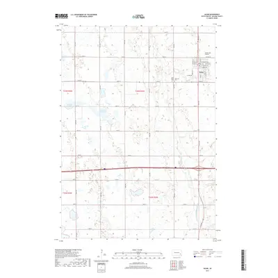
2017 Map of Salem
USGS Topo · Published 2017About this map
Salem serves as the central hub of this McCook County landscape, situated where the high terrain of the Coteau des Prairies begins its gradual descent. The town's grid is established around N Main St and Center Ave, with local history anchored at the Saint Mary's Cem and Wildwood Cem on the eastern outskirts. The surrounding prairie is defined by a complex glacial hydrology, characterized by numerous depressions and wetlands like Tuschen Slough and Schimmel Slough. To the south and east, the drainage network of the W Fork Vermillion River carves a path through the township, illustrating the relationship between the regional watershed and the agricultural sections. This survey provides a clear look at the intersection of early settlement patterns and the natural water bodies such as Macke Lake during the early 21st century.
Find a feature on this map
41 named features on this map. Tap any name to fly to it.
Don’t see what you’re looking for? This feature index may not catch every label — zoom into the map to look around manually.
Map Details
Editions of this 2017 Salem Map
This is the sole edition of this map. No revisions or reprints were ever made.
Other maps of this area

1899 · Alexandria
USGS Topo · 1:125,000

1955 · Sioux Falls
USGS Topo · 1:250,000

1958 · Sioux Falls
USGS Topo · 1:250,000

1964 · Canistota
USGS Topo · 1:24,000

1964 · Salem NE
USGS Topo · 1:24,000

1964 · Salem
USGS Topo · 1:24,000

1964 · Bridgewater East
USGS Topo · 1:24,000

1971 · Unityville
USGS Topo · 1:24,000
1971 · Winfred SE
USGS Topo · 1:24,000
1973 · Bridgewater West
USGS Topo · 1:24,000