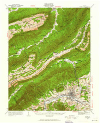
1929 Map of Salem
USGS Topo · Published 1962About this map
Salem anchors the southern portion of this landscape, situated along the Roanoke River where the Norfolk and Western Railway facilitates early 20th-century commerce. To the north, the terrain is defined by dramatic ridgelines including Catawba Mountain and Fort Lewis Mountain, which isolate small rural communities and mountain coves. The map documents a significant healthcare landmark at the Catawba Sanatorium, complete with its own dedicated rail station. Local industrial and social life is evidenced by Webbs Mill and Kesslers Mill, alongside numerous rural institutions like Shiloh School and Johnsville Church. Natural landmarks such as McAfee Knob and the curiously named The Murder Hole stand out amidst the complex topography of Millers Cove and Jefferson Cove. The intersection of the river valley's development and the high-elevation settlements reflects the region's historical reliance on both mountain agriculture and rail-driven industry.
Find a feature on this map
94 named features on this map. Tap any name to fly to it.
Don’t see what you’re looking for? This feature index may not catch every label — zoom into the map to look around manually.
Map Details
Editions of this 1929 Salem Map
2 editions found

Other maps of this area

1887 · Lewisburg
USGS Topo · 1:125,000

1890 · Roanoke
USGS Topo · 1:125,000

1890 · Christiansburg
USGS Topo · 1:125,000

1891 · Roanoke
USGS Topo · 1:125,000

1891 · Lewisburg
USGS Topo · 1:125,000

1894 · Natural Bridge
USGS Topo · 1:125,000

1913 · Eagle Rock
USGS Topo · 1:48,000

1915 · Eagle Rock
USGS Topo · 1:62,500

1921 · Ronceverte
USGS Topo · 1:48,000

1923 · Ronceverte
USGS Topo · 1:62,500