
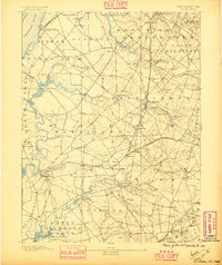
1890 Map of Salem
USGS Topo · Published 1890About this map
The Salem waterfront and its surrounding farm townships reflect a landscape deeply integrated with the rail networks of the late nineteenth century. Surveyed by C.C. Vermeule under the direction of George H. Cook, the sheet details an era when local commerce moved via the Swedesboro and Woodstown and the Philadelphia and Salem Branch railroads. The topography is dominated by the meandering course of Salem Creek and Alloway's Creek, which carve through the lowlands of Mannington and Alloway. Notable elevation is found at Big Mannington Hill, providing a rare vantage point over a region otherwise defined by its tidal marshes and fertile creek-bottoms. Small clusters of industry and settlement are evident at locations like Avis Mills and Hancock's Bridge, showing the distribution of rural life before the twentieth-century expansion of the Delaware River industrial corridor.
Find a feature on this map
89 named features on this map. Tap any name to fly to it.
Don’t see what you’re looking for? This feature index may not catch every label — zoom into the map to look around manually.
Map Details
Editions of this 1890 Salem Map
2 editions found
Other maps of this area

1890 · Bay Side
USGS Topo · 1:62,500

1890 · Bridgeton
USGS Topo · 1:62,500

1890 · Glassboro
USGS Topo · 1:62,500

1891 · Philadelphia
USGS Topo · 1:62,500

1894 · Bay Side
USGS Topo · 1:62,500

1894 · Bridgeton
USGS Topo · 1:62,500

1894 · Chester
USGS Topo · 1:62,500

1894 · Philadelphia
USGS Topo · 1:62,500

1896 · Philadelphia
USGS Topo · 1:62,500

1896 · Chester
USGS Topo · 1:62,500