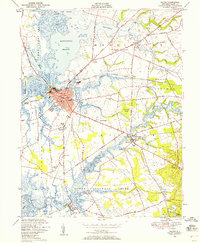
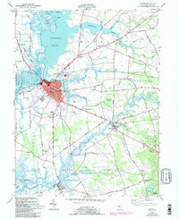
1948 Map of Salem
USGS Topo · Published 1958About this map
Salem's industrial and maritime character is defined by the confluence of the Salem River, Fenwick Creek, and Keasbeys Creek, where the city's red-tinted urban core meets expansive marshlands. This mid-century survey captures the region's transport network at a transition point, with the Pennsylvania Reading Seashore Lines serving the riverfront while an evolving road system connects outlying hamlets like Quinton and Hancocks Bridge. The landscape is dotted with educational and social markers of the era, from the Town Hall Sch and Wyncoop Sch to the Salem Airport and Athletic Field. To the north and west, the vast Mannington Meadow and Stoney Island Meadow emphasize the tidal nature of the county seat's surroundings, punctuated by landmarks such as Majors Wharf and the Evergreen Cem at the city's southern edge.
Find a feature on this map
75 named features on this map. Tap any name to fly to it.
Don’t see what you’re looking for? This feature index may not catch every label — zoom into the map to look around manually.
Map Details
Editions of this 1948 Salem Map
5 editions found
Other maps of this area

1890 · Salem
USGS Topo · 1:62,500

1890 · Bay Side
USGS Topo · 1:62,500

1894 · Bay Side
USGS Topo · 1:62,500

1898 · Salem
USGS Topo · 1:62,500

1899 · Vineland
USGS Topo · 1:125,000

1899 · Dover
USGS Topo · 1:125,000

1901 · Camden
USGS Topo · 1:125,000

1904 · Wilmington
USGS Topo · 1:62,500

1906 · Dover
USGS Topo · 1:125,000

1906 · Wilmington
USGS Topo · 1:62,500
Featured Places
- Pennsville Township, NJ
- Salem, NJ
- Quinton Township, NJ
- Lower Alloways Creek Township, NJ
- Alloway Township, NJ